Posts

Showing posts from 2010

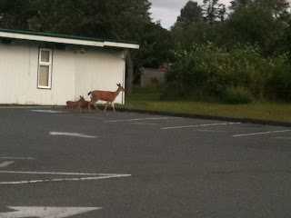
You Know Your Bored When....

Image
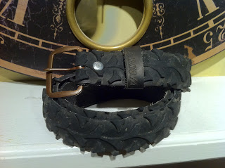
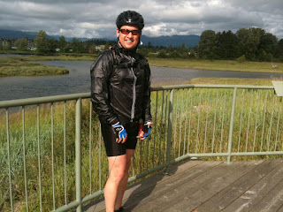
Well the rides are few and far between.  The weather has been less than cooperating and being a fair weather rider (actually I don't have time to meticulously clean my bike), I've been avoiding going out in the rain.  Well, I convinced myself that if I don't go, I'll get FAT so I figured that I'll need to buy new cables, chain, pulley wheels in the spring anyway so into the rain I go!  Dressing for it is another matter...and I look like I've gained back all those pounds that I cycling off this spring, but its just hi-tech layers to keep me dry, or at least semi-dry. With my other 6-8 hours/week of not training its being replaced by more creative or mundane things like making  cycling  caps.  I can't get the brim right or the bottom of the hat straight.  I'm on my 5th hat and they still suck to show anyone.  On the other hand, I just made 2 bike tire belts.... And they look pretty good if I say so myself.  Even my socially conscious son wanted a set.  I

Virtual Tour stop at Terrace Bay, ON

Image
3225km and 135 hours of riding has landed me in Terrace Bay.  I'm 225km past my year goal and feeling pretty smug about myself.  This stop is at Terrace Bay on the northern shores of Lake Superior.  Here's the WIKI story on my stopover.   Terrace Bay is a township in Thunder Bay District in northern Ontario located on the north shore of Lake Superior east of Thunder Bay. The name originates from a series of lake terraces formed as the water level in Lake Superior lowered following the latest ice age. My training is in recovery mode to slow down and look at the scenery and to enjoy the last sunny days during the fall months.  Pretty soon Highways will be applying the dreaded liquid salt which will eat at the very being of my bike.  It was a frosty morning last weekend and I'm not far from calling it a season.   

Thunder Bay, Here I Come!

At 2865km, I've passed Winnipeg about 500km ago.  Nothing was really missed there.  The Ontario border was about 400km away and today I coming up near Upsala.  Upsal....what?  Yep theres a name for anything.  Wiki says: Upsala is a township in Thunder Bay District in northwestern Ontario. It is located on the Trans-Canada Highway, Highway 17, 142 km west of Thunder Bay. It was named after the city of Uppsala in Sweden. When established in 1882, Upsala was an important fuel and water stop for trains travelling on the then newly constructed Canadian Pacific Railway system. The Upsala area is situated just north of Lac des Mille Lacs, which was an important fur trade waterway and today is home to many fishing and hunting resorts. Thunder Bay is in my sights and well within my goals of 3000km for the year.  I'm considering traveling Route 66 next year for a new virtual tour adventure.  Sorry Canada, the prairies killed me due to the lack of adventure and diversity.  You're

In a month, I can work wonders

Image
Has it been a month and half already?  Over the last month, I've ridden 2,826km and 117hours in the saddle.  I'll update my virtual tour next post.  The marquee event for me was the Granfondo which was from Vancouver to Whistler. It was astounding and certainly surreal  to be riding the Sea to Sky Hwy without the worries of cars going 100km/hour.  It was well worth the money and I'll probably go in it next year. Position Bib Name Team name Start time Split 1 Split 1 Pos. Split 2 Split 2 Pos. Finish time Elapsed time Avg speed (KM/H) Compare 1653 2274 Warren Hansen Fancy Beer 7:12:32 02:39:10 3150 03:28:34 1246 12:11:46 04:59:14 25.22

Manitoba is almost the same as Saskatchewan

Image
My virtual tour across Canada leads me into Manitoba and I'm still in the prairies.  2135km from Horseshoe Bay and 89 hours in the saddle.  I'm just a little past Brandon, MB and obtained a little picture to remember it by.   Wiki says the following about the place:    Brandon  is a city in southwestern  Manitoba ,  Canada . The surrounding area is often referred to as " Westman ". The city started as a major junction on the  Canadian Pacific Railway , and the Assiniboine River  and was then incorporated in 1882. Brandon, the second largest city and service centre in Manitoba after  Winnipeg , is a major hub for the surrounding agricultural area. The population of its trading area is between 70,000 and 150,000 people, while the city has a population of over 46,000. Brandon's industry reflects its agricultural history; its major industries are related to agriculture and include fertilizer and hog processing plants, as well as retail and government services for t

If you're going through Saskatchewan, you're bound to run into a Indian Head

Image
My virtual cycling tour across Canada landed me just west of "Indian Head" at 1801km from Horseshoe Bay, BC.  Indian Head? Yep I kid you not!  And what does every town need when named from a First Nation's part of their anatomy - a INDIAN HEAD?  YEP!   Indian Head is a town in southeast Saskatchewan, Canada, 69 km east of Regina. The town is directly north of the Trans-Canada Highway. The town is known for its federally-operated Prairie Farm Rehabilitation Administration (PFRA) experimental farm and tree nursery that produces seedlings for shelter belts.   So  there you go.  I've been riding into the darnedest towns!   ---WAB1234---

Moose Jaw - Wonder where the name came from

Image
My virtual tour lands me in Moose Jaw at 1663km across Canada.  How did this place get its name? Wiki (gotta love Wiki!) says "Marked on a map as  Moose Jaw Bone Creek  in an 1857 survey by surveyor John Palliser, [ 1 ]  there are two theories as to how the city got its name. The first one is that it comes from the  Plains Cree  name moscâstani-sîpiy  meaning "a warm place by the river", indicative of the protection from the weather that the  Coteau Range  provides to the river valley containing the city [ 2 ] and also the  Plains Cree  word Moose Gaw  meaning warm breezes. The other is that on the map of the city the Moose Jaw river is shaped like a  moose 's jaw." I like the first version rather than the obvious.  Traveling luck has a better break down of Moose Jaw here  .  Of course every town aptly named from a moose's anatomy should have a giant statue of it!      Regina is a mere 70km away and Winnipeg is 550km.  There is a whole load of km still t

280km in Two Day on the Circle Tour

Image
280km and 11:29:40 in two days defines the circle tour around the Georgia Basin aka the Circle Tour.  To summarized my event on the Saturday, I got off the ferry and realized that I only had 40km to complete a Century which is the definitive event in a cyclist goal bucket list.  I picked out my route and ended up completing 160km (100miles) at the end of the day.  To give a better perspective of the distance, just jump in the car at Horseshoe Bay and drive east on the HWY 1 for a little less than 2 hours and you'll hit 160km just outside of Hope, BC.   Anyway, the next day was start of a 120km trip down the coast on the old island hwy and for all intents and purposes I was cycling into headwind all the way!!!! (Actually I just checked the weather data and it was a 30km headwind which equates to a 4% grade uphill for effort).  Here's some pictures:   Picture 1 - Deer and two fawns in Comox Picture 2 - In between Comox and Courtney on the river.  Picture 3 - Fanny Bay Pic

Second day of the Circle Ride starts with Sun!

Image
A great start to the ride in Comox. I've done about 161 km and 6 hour 35 min of riding. 120km to go to Nanaimo.

2nd leg done at Powell River

Image
11:00 am June 26. Whew! Completed the second leg of my journey and I'm at 118km and 4:41 hours into it. This second leg was really pleasant with almost no highway traffic and wide shoulders. I felt really safe here. The shoulder was pretty clean compare to highway 101 near Sechelt. On to Comox and to visit friends to end day ones adventure.

Made it to Earls Cove

Image
Well I'm 85 km into my first day and it's 7:50am in morning! Completed to date - 3:24:31 time, 85.61 km, 25.1 km per hour. Well the first leg was awesome although it didn't start too well. I woke up at 2:45am and took my time to put everything together. Went through my checklist, yep all good to go. I left the house at 4am and it was very dark which required me to use some lights. The first 1/2 hour in the dark was a bit eerie because it was so quiet. About 10 min into the ride I needed a drink of water and no water bottles. Man! It wasn't on my list! So I realized that nothing was open in Gibsons at 4:30 am except for Timmy's which had these pathetic water bottles. Good enough I said and shelled out $3.45 (rip off). There was almost no traffic most of the way which I counted 10 cars. I'm now waiting for the 8:25 ferry where I'll rest, stretch, get sugared up and ride to Powell River for 30km.

Test blog entry

Today is my big two day ride. Will be testing and sending pictures of my trip along the way. ---WAB1234--- Sent from my iPhone

Whats in Suffield Alberta?

Image
June 20 of my Virtual Tour and its the same thing - Flat as hell and grasslands every where!  I end this week just outside Suffield Alberta.  1237km and 51 hours of riding.  Traveling Luck doesn't have much to say about this area.  Except for the Armed Forces Base just north of here, its not very exciting....  http://travelingluck.com/North+America/Canada/Alberta/_6158870_Suffield.html#local_map   ---WAB1234---

Virtual Tour stop at Hwy 842 - Theres Petro Canada Station here

Image
My virtual tour stop of the week at 1082km is at the junction of Hwy 842 and the Hwy 1.  I went on Google Maps and into street view.  There's truck stop and Petro Canada here!  Woo-Hoo!  South on Hwy 842 is the town of Cluny, or something of a town which looks haunted.  A little further south is Blackfoot Crossing Historical Park on the Bow River .   ---WAB123---

Right through Calgary and stopped in Chestermere Lake

Image
My virtual tour this week took me from the Rockies right through Calgary and into Chestermere Lake.  Wiki says Chestermere Lake  is a man-made  reservoir  in  Chestermere ,  Alberta ,  Canada . It was built in the 1880's by the  Canadian Pacific Railway , for irrigation of the area between  Calgary  and  Strathmore . It is presently used mainly for recreation purposes, such as swimming, windsurfing, fishing and skating (in winter). The town of Chestermere surrounds the lake on three sides. The  Trans-Canada Highway  follows the northeastern shore, while the railway tracks pass by the southern shore. The lake covers a surface of 2.65  square kilometres  and has a maximum depth of 7 metres . [1]  It drains into two irrigation canals and is filled via a canal from the  Bow River . The phrase "Chestermere Lake" is actually inaccurate as " mere " means lake in English. With " Chester " an English word derived from the Latin for a defensive fort and meanin

Almost Sideswiped.

I meant to write about this for a while.  About a week ago, I was just doing my regular riding route on the highway and a purple F150 brushed me (about a foot away from the mirror) and then suddenly turn right in front of me.  All I could do was jam my brakes on and yell at the top of my voice.  The driver kept driving up the road probably not even aware of the almost carnage that could have occurred.  I felt incensed! Pissed off! and woefully helpless....I felt that I should have track the person down and let him know that the driver was in the wrong or something like that. After a week of thinking about it, I believe that it was an honest mistake and something that any driver of automobile wouldn't get how I feel unless they could feel that their life was in jeopardy too.  Something like if their brakes failed or someone was in their lane heading towards them in a head-on collision.  At least, a head-on would get their attention whereas hitting a bike rider would even dent the qu

What the???? Eldon, Alberta?

Image
My virtual bike ride across Canada is at 832km and has me landing in Eldon, Alberta -  Its seems that Eldon is just a small group of houses.  Let see where next week will take me....on WAB1234's tour across Canada! This is Boom Lake just outside Eldon.  Click the link for information on Eldon  http://travelingluck.com/North+America/Canada/Alberta/_5947456_Eldon.html#local_map  

Getting Ready for the Circle Ride

I've put about 742km into training this year since April  and I've mapped it on Google maps.  Right now I would be just outside Golden on the BC border and well into the Rockies!   Google Map link   I checked my progress last year and at this time I put in about 1110 km in. 400 less km but I'm about 1km/hour faster on average in 2010, so I'm doing better and more intense workouts.   I've established two goals this year.  1) June 26 and 27.  The circle ride from Gibsons to Powell River to Comox to Nanaimo.  This journey is 240km and I'll do it in 2 days.  It is possible to do it in 1 day but the ferries schedule sort of screws up the day.  I'll look at the summer schedule to see if it can be worked out in the summer schedule in August.   2) The Granfondo in September. ---WAB1234---

Starting to get excited about riding again.

I'm just starting to get into the groove of riding on the coast.  There seems to be greater enthusiasm this year versus other years as several people have approached me to go riding seriously.  A couple of ideas we have floated around is to do the Circle Ride (Powell River, Courtney, Nanaimo, Gibsons loop) which is 240km and 10-12 hours of riding in two days.  Actually one of the riders would like to do it in one day!!!!  I don't want this to be a rite of passage into a mid-life crisis as the suggestion came from a former Canadian Cycling Champion (who is bionic by the way).  I would like to enjoy the ride and two days will just about do it.  June 26, 27 could be the dates for some fun! Other ideas is a small toonie criterium race around the blocks in Sechelt.  The race format is 20 laps and if you are lapped then you're out.  They can get a bit dangerous around corners and with bunch of people....maybe not...but lots of interest in racing though!  Maybe we'll stick t

Just registered to ride in the Whisler Granfondo Event!!!!

Image
I needed a goal and it wasn't simple to decide.  First there was a possible duathlon at UBC.  I'm not a strong runner and actually despise it, but it would have been a necessary evil.  The date was coming soon and I haven't even tried running.  So, its becoming a passing thought. My friend, Dave sent an email of a ride from Vancouver to Whistler called the Granfondo which means big ride. He also said that there were only hundred spaces left of the 3500 spaces for the ride.  So I started entering information on my Iphone but hadn't finished the registration yet.  A day later after mulling the idea with my wife and with her support, I jumped on the computer to register and the website said "Sold Out!".  Oh man I was beyond bummed out!!!  Then I remember my phone registration and voila! the session was still active.  I put my information back in and credit card number and the website accepted my payment and a confirmation came in the mail!!!!!  Woo Hoo!!!!!  Ho

Its was blue but now red!!!!!

Image
My bike is finally finished!  In October, my old bike developed a crack in the seat tube.  I was wondering where the creaking was coming from for months and in October it was driving me crazy.  A closer inspection revealed a small 1 1/2" crack at the back of the seat tube at the bottom of the notch (below the collar clamp).  I took it to Spin Cycles and Paul immediately put the papers in and order a new bike frame.  Because the bike was so popular, a new bike frame had to come from somewhere far away, and get this, the bearing had to come from the factory in Arizona!!!  So, in January I had a frame, but the forks had to come from Taiwan and that came in March.  I put on some nice red cables and new red wrap on the handlebars.  I'm using a buddy's set of used Mavic ES wheels and man does this bike look great!!!! Gone is the creaking and the wheels make this one fast bike!  I'm so charged up to ride this year!

Happy 2010!

I need a goal. A duathlon? Ride to Conquer Cancer? In the coming weeks, I will be deciding.